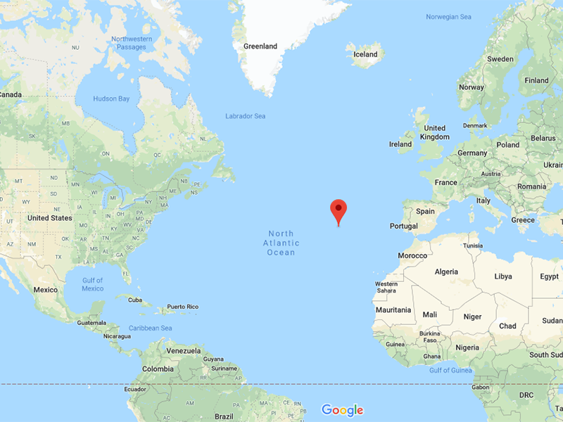
Trying to figure out where are the Azores? Don’t worry because many travelers aren’t sure either and we’re here to help! This remote archipelago of 9 islands and 8 formigas (Portuguese islets) lies in the North Atlantic Ocean about 1500km (930 miles) due west of Lisbon, Portugal and 3380km (2100 miles) east of Washington D.C. in the USA.
The islands lay between 36° and 43°N Latitude and 25° and 31°W Longitude and they cover an area that extends for over 600km (373 miles). If you look at the Azores islands map, you will see that they lie roughly northwest-southeast in orientation.
WHERE ARE THE AZORES: AN INTRODUCTION
The autonomous region of the Azores is regarded as the westernmost point of Europe which can be seen on any Azores islands map as the islands are in the middle of the Atlantic Ocean. As well as being a major port of call for transatlantic vessels, the main industries on the Azores are tourism, fishing, cattle and dairy farming.
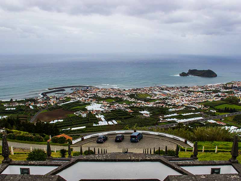
The capital city of the Azores is Ponta Delgada on São Miguel island. Visitors will find the city pleasant and easy to explore with European shops and stores lining the marble-cobbled streets. The population of the Azores in 2011 was just 246,772 and the currency is the Euro.
Due to their remoteness and self-containment, the islands have very little violent crime, although there is a small amount of petty crime, theft and drug-related incidents, but this happens anywhere in the world, and overall the islands are super safe and tourist friendly.
Read on for more specific information on where the Azores are located. Or jump ahead to figure out the Best Azores island for you.
WHERE ARE THE AZORES VIA MAP COORDINATES AND DISTANCES?
The main airport in the Azores for those arriving by air is Ponta Delgada (PDL) Airport on São Miguel island.
Lajes Field (TER) on Terceira island is an international airport and U.S. Airforce base. The islands on Faial (HOR) and Pico (PIC) also have airports for mainly inter-island flights.
The islands’ main airline is Azores Airlines which connects the islands with Boston, USA and mainland Europe. It is part of SATA Group which also offers flights to Canada, London, Amsterdam, Paris, Frankfurt, the Canaries and Madeira. Portugal’s TAP airline flies between Lisbon and just began flying direct from Ponta Delgada to Boston. Check out more info on Azores flights, including a free stopover.
Ponta Delgada, Sao Miguel map coordinates are:
- Latitude: 37° 44′ North
- Longitude: 25° 40′ West
If you’re trying to figure out where exactly the Azores are, here are some distances from the major cities that fly to the Azores:
- Lisbon, mainland Portugal: 1449km, 900 miles
- London, England: 2517km, 1564 miles
- Boston, USA: 3861km, 2399 miles
- Oakland, California, USA: 8063km, 5010 miles
- Toronto, Canada: 4507km, 2801 miles
WHERE ARE THE AZORES VIA MAPS AND LOCATIONS?
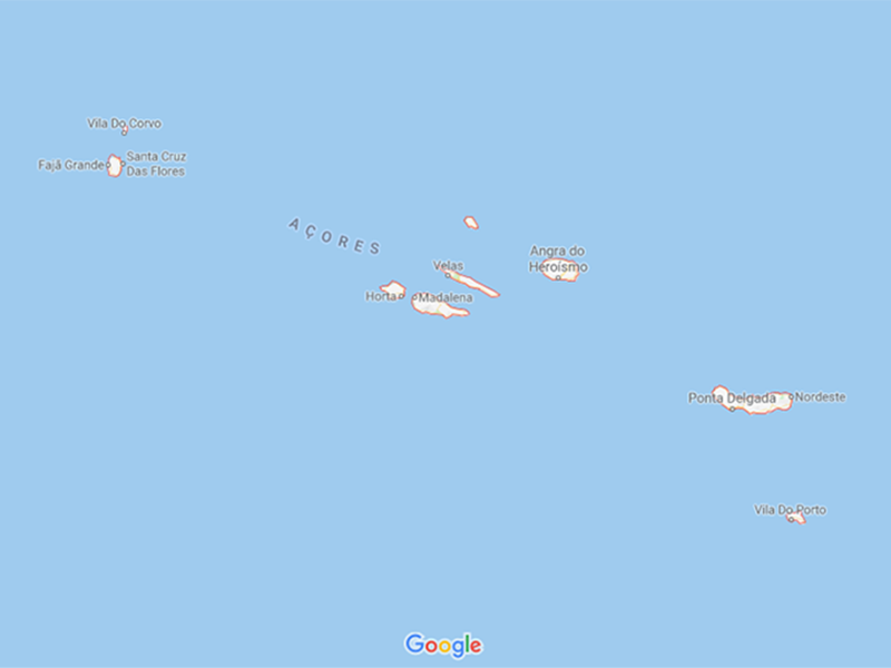
To find out where the Azores are, it’s helpful to look at an Azores islands map. You will see that the islands are divided naturally into three main groups:
- To the east are São Miguel, Santa Maria and the Formigas Reef.
- In the center of the archipelago you will find Graciosa, Terceira, São Jorge, Pico and Faial.
- The two remaining islands of Flores and Corvo mark the westernmost point of Europe.
Each of the nine major islands has its own distinct character and geography. We provide a brief overview of each island shown Azores islands map below.
Where are the Eastern Azores?

São Miguel
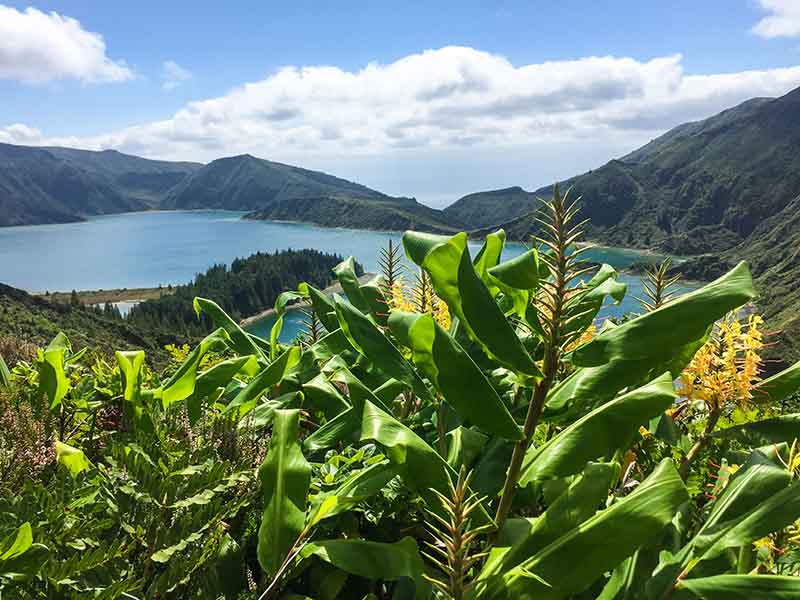
Covering 759km², this is the largest and most populated island in the Azores. Nicknamed the Green Island for its lush vegetation, it is home to the capital, Ponta Delgada. Major natural attractions include whale and dolphin watching, 20+ amazing beaches, the Lake of Fire (Lagoa do Fogo), the green pastures in the Picos region, hot springs and the volcanic debris field that bridges the two massifs that make up the island (Sete Cidades Massif and Agua de Pau Massif).
Santa Maria
Generally warm and dry, Santa Maria has white sandy beaches and chimney rock formations. It is home to the European Space Agency satellite tracking station.
Where are the Central Azores
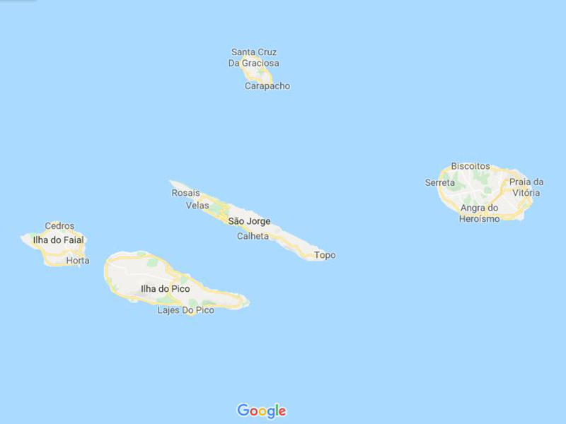
Graciosa
Known as the “White Island” Graciosa is dominated by a mile-wide caldera. The main town of Santa Cruz has charming Portuguese architecture including a historic church.
Terceira
The second largest island on the Azores map, Terceira is home to the Azores’ oldest city, Angra do Heroísmo, the historical capital of the archipelago and a UNESCO World Heritage site.
São Jorge
This long, thin island has tall cliffs, a pretty church built in 1460 and celebrates many cultural festivals. It’s also known for its cheese, and has great hiking.
Pico
At 446km², Pico is the second largest Azores island and home of the highest mountain in Portugal, the Ponta do Pico. It is nicknamed the Black Island due to the black volcanic earth which is favored by historic UNESCO-listed vineyards (the wine is fantastic!). It has three main volcanic peaks. The capital is Madalena and the island has received a Gold Award for sustainable tourism.
Faial (Pronounced “fayal”)
Faial is part of “The Triângulo” with Pico and São Jorge. Popular for tourists, it features Faial Nature Park, Capelinhos Volcano and a cool lighthouse.
Where are the Western Azores?
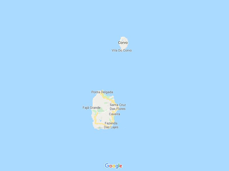
Flores
With an abundance of wild flowers (hence its name) Flores has many lake-filled craters on the Central Massif. Nearby Monchiquet islet is the westernmost point of Europe.
Corvo Island
Known as the Island of the Crow, Corvo is the smallest and northernmost island on the Azores map. It features sheer cliffs, ancient lava flows and the protected Caldeirão volcanic crater.
DISTANCES BETWEEN MAJOR CITIES
In addition to learning where are the Azores, it’s helpful to understand the distances between the island.
- Santa Cruz Das Flores (West Azores) to Velas (Central Azores) 266 km / 165 miles
- Velas (Central Azores) to Ponta Delgada (East Azores) 45km / 152 miles
- Ponta Delgada (East Azores) to Santa Cruz Das Flores (West Azores) 511km / 317 miles
Sao Miguel inhabitants have a distinct accent unlike anywhere else in Portugal. English is also widely spoken due to this being the main tourism destination.
HOW LOCATION OF THE AZORES ISLANDS AFFECTS CLIMATE
The Azores islands have a mild, temperate climate with the warming effects of the Gulf Stream giving them one of the mildest winters in Europe. Throughout the year temperatures in the Azores range between 16°C (61°F) and 25°C (77°F). They never see temperatures above 30°C (86°F) or below freezing in the main, populated areas. Ocean temperatures range from 17°C (63°F) in winter to 25°C (77°F) in summer.
Although the surrounding seas on the Azores map have a favorable influence on air temperatures, it also means that the climate in the Azores is generally humid, wet and cloudy. The islands have an annual rainfall totaling 958mm (37 inches), mainly in the winter months. If you want to know the best time to visit, checkout our month-by-month comparison.
HOW THE AZORES WERE FORMED
Now that you have a better sense of where are the Azores, you’re likely wondering, how did the islands originate so far from other land?
The Azores are steep and rocky which gives a clue to their formation. They are the result of volcanic activity below the sea along the Azores Triple Junction and the Terceira Rift. The most recent volcanic activity was in 1957 when the Capelinhos Volcano erupted offshore from Faial Island.
The islands you see on the Azores islands map are in fact the tips of some of the tallest mountains on the planet, although most of the landmass is underwater. Mount Pico on Pico Island is the highest point in Portugal standing 2,351m (7,713 feet) above sea level. So imagine how high that mountain actually is when measured from the ocean floor!
It is thought that the first and oldest island to be formed was Santa Maria, 8 million years ago and the youngest is Pico, which was formed 270,000 years ago. However, following the volcanic eruption in 1957, a new islet was formed and named Sabrina Island. You won’t find it today on any Azores islands map as it quickly sank back into the sea.
Some of the most interesting sites for visitors to the Azores are the result of ancient volcanic activity. These include lava tubes, hot springs, black sand, vivid blue and green lakes and coastal lava fields.
This unique landscape makes the Azores a phenomenal place for hiking and other outdoor activities.
HISTORY OF THE AZORES ISLANDS
Now that you have a better idea where are the Azores, we’d like to give you a quick overview of the islands’ history. The Azores Islands were first permanently settled in 1492 after being recorded on an early map of Gonçalo Velho, a captain sailing under the orders of Prince Henry the Navigator. He claimed the islands for Portugal and named them after the açor (goshawk), a bird which was common at the time, although not necessarily found on the Azores.
Early Settlers
Over the next two centuries, more people settled on the islands from many different places, giving the Azores a remarkably diverse and unique culture, dialect and cuisine. As any Azores islands map will show, due to their isolated location, the islands did not have too many people who were eager to settle there.
Sheep were introduced for meat and the early settlers had to clear the land, planting grain, sugar cane, grapes and plants for food. Gradually they introduced chickens, pigs, rabbits, cows and goats to enable them to be self-sufficient.
However, these people may not have been the first inhabitants to reside on the Azores. Archaeologists found earthen structures carved into the rocks that may be the burial chambers of inhabitants dating back over 2,000 years.
Overcoming Devastation
In 1522, the Azores Islands were devastated by an earthquake. The resulting landslide hit Vila Franca do Campo, the early capital, taking 5,000 lives. After the earthquake, Ponta Delgada became the capital, and today Vila Franca do Campo is a thriving port and hub for ocean-going yachts and fishing boats.
After the earthquake, the islands rebuilt and have now long attracted writers, philosophers and more than one pretender to the Portuguese throne!
As you can see in the Azores island map, the islands hold a strategically important and unique position in the mid-Atlantic ocean. The islands were used in World War 2 as an air and naval base for the Allies. And the U.S. Navy still maintains a fleet at Praia da Vitoria today.
In 1976, the Azores Islands became an Autonomous Region of Portugal.
WHERE ARE THE AZORES: CONCLUSION
We hope we’re answered your where are the Azores questions and our Azores island map has been a useful resource. If you’re keen to visit the islands, Travel Honey can make it happen!