Azores hiking is an amazing way to see the nine-island archipelago. Each Azores island has well-marked and well-maintained trails. On your Azores hike, you can take in the many beautiful vistas, meander through lush forests, and visit magical water falls. So if you want to know everything you need to know about Azores hiking, this is your guide! We breakdown the Azores hiking by island and offer first-hand experience about each hike on Sao Miguel island.
Types of Azores Hiking Trails and Which Websites and Apps to Use
The primary Azores hiking trails are classified and maintained by the Regional Government of the Azores. These can be found on the Visit Azores website and the Visit Azores app (iOS app and Android app). To access: Open App> Explore > Experiences > Walking Trails).
On each platform, the trails can be searched by island. Also, each of the Azores trails has a code. The codes with “PR” are linear trails and those with “PRC” are circular. A difficulty rating and estimated time is also listed for each trail. These ratings though, are not always accurate. The difficulty is mostly based on the estimated times. So, make sure you also check the elevation gain at the bottom of the page on the website to see the steepness. Also, if you’re in good shape and don’t take long breaks, you can usually finish the hike in less time than is listed.
There are also municipal trails, which are not on the Azores Trails website or Visit Azores trails. Checkout our guide and interactive map, which includes a few municipal trails
An Overview of Hiking Options on Each Azores Island
First, just as a little background on the Azores. The Azores is a nine island archipelago of Portugal. The islands are located about 930 miles west of mainland Portugal and 2400 east of Boston (maps of the Azores).
There’s not one best Azores island, but if you want the most hiking trails, head to Sao Miguel. If you want harder hikes and fewer people, try hiking on Sao Jorge.
Note, all of this information is current as of this post’s published date. Azores trails are often closed for cleanup and repair. Check the Visit Azores website for the most up to date information. We’ve listed the Azores islands from the most to fewest regional hikes.
Sao Miguel Hiking Overview
Sao Miguel island has the most hikes of any Azores island. There are 29 active regional hikes on Sao Miguel. Most are rated easy and medium difficulty. Despite that rating, most hikes still have a steep portion. So prepare those quads!
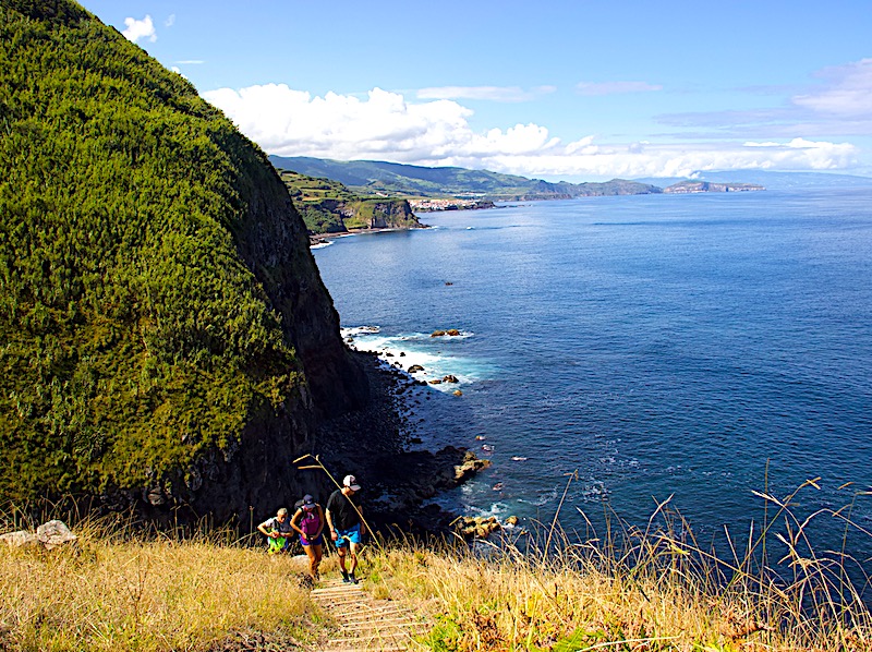
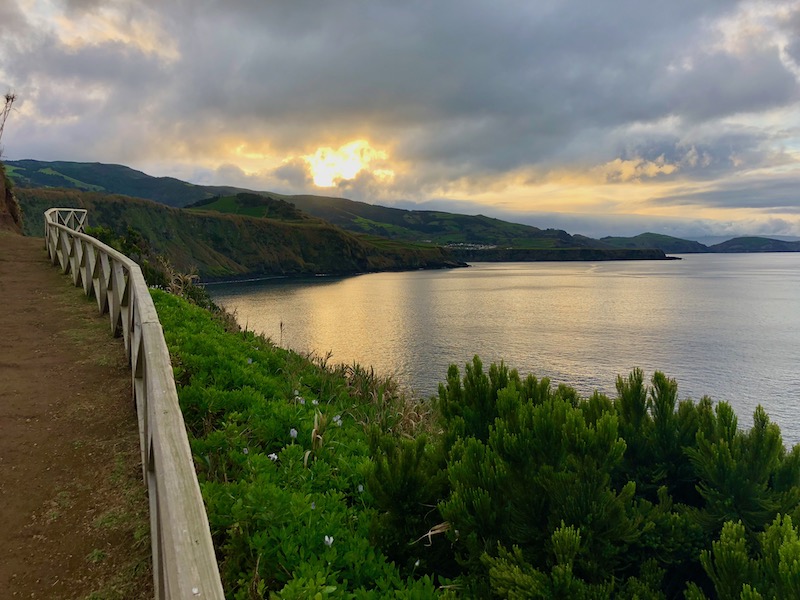
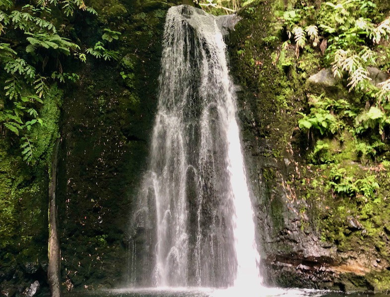
Because there are so many hikes on Sao Miguel, you can find a lot of variety. Most hikes along the north coast have beautiful ocean vistas. A number of the hikes have stunning water falls, some of these you can even swim in. Sao Miguel also has great hikes in the forest, which are good for if the weather is bad.
See below for details about each Sao Miguel Hike. [ADD LINK]
Pico Hiking Overview
Pico is the second largest Azores island and has about 15,000 residents. Pico’s landscape is one of more distinct of the Azores islands. It’s largely beach-less. Instead, it’s shores are mostly hardened lava. Pico is also known for its wine and intricate stonewall vineyards crisscross the terrain. Finally, Pico boasts the highest mountain in Portugal. Mt. Pico is a 7,713’ volcano that dominates its skyline.
Pico has 12 regional hikes, which include a number of easy trails. But check the elevation gain, because some of the easy hikes still have steep parts. The Vinhas da Criacao Velha hike though, is flat and relatively easy. It takes you through Pico’s famous vineyards.
Although not a regional hike, many visitors come specifically to hike Mt. Pico. You can hike Mt. Pico on your own but you have to register and rent a GPS device. There’s a visitor center, so they’ll be able to get info there and the trail is well marked. But a guide is helpful if it’s foggy and hard to see the markers or if you want to do an overnight hike or at sunrise. The weather can change (and even snow in May!), so be prepared either way.
Sao Jorge Hiking Overview
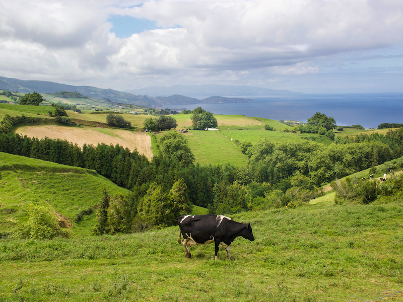
Sao Jorge is the fourth largest Azores island but has significantly fewer residents (6,000) compared the other islands of comparable size. Sao Jorge is long, narrow, cliff-lined, and is known for its cheese. It’s also where more serious hikers head if they want to get off the beaten path when hiking in the Azores.
Sao Jorge island has 10 regional hikes, including one Grand Route. Sao Jorge’s hikes tend to be longer and more difficult. 7 out of 10 of the hikes are over 9km long. The hikes are also either rated medium or hard. The hikes are a mix of circular and linear. Since the island is so long and narrow, all of the hikes have amazing ocean views.
Azores Hiking Options on Faial Island
Faial is the fourth largest Azores island and has about the same population as Pico (15,000). Faial is known for its harbor and many boats stop there while crossing the Atlantic. Faial also has two beaches, one is walking distance from the center of Horta, the biggest town.
Faial has 10 regional hikes, including one Grand Route that goes from coast to coast. Faial has a good mix of various length hikes and also a mixed level of difficulty. One not to miss hike, is hiking the stunning caldeira. There are two ways to hike the hike caldeira. You can walk around the rim on a regional trail: Caldeira – Faial – PRC04 FAI. Or, if you want to go down into the caldeira, you must go with a guide. Either way, be prepared for low visibility, as the caldeira is often fogged in.
Azores Hiking Options on Terceira Island
Terceira is the third largest Azores island and second most populated (60,000). Terceira is known for its culture and festivals. Terceira also has two beaches, including one in Angra do Heroísmo, a UNESCO World Heritage site.
Terceira island has 8 regional hiking trails, mostly circular. The hikes range between 3.8km to 8.8km long and are rated a mix of easy, medium and hard. The hikes have both coastal and inland forest landscapes.
Azores Hiking Options on Santa Maria Island
Santa Maria is the southernmost Azores island and third smallest. It’s typically the warmest and sunniest. It’s also one of the few Azores islands with white sandy beaches. If you like blues, you can pair hiking with Santa Maria famous blues festival in the summer.
Santa Maria has 7 regional hikes. One of these hikes is the Faial Grand Route, and is 78km long! The other six hikes are between 11.5km and 4.1km. All but one of the hikes are rated medium difficulty. There is a mix between circular and linear hikes but they all have at least one ocean view
Azores Hiking Options on Flores Island
Although all the Azores islands are lush and green, Flores looks the most like a tropical island. Flores is also one of the more remote Azores islands. There are few accommodations and travelers often camp to see the island.
Flores has 5 regional hikes, which are all rated medium to hard. Including, one Flores Grand Route, which is 48km and is estimated to take 18 hours.
Azores Hiking Options on Graciosa Island
Graciosa is flatter than its neighboring Azores islands and is agriculturally focused. Graciosa has 4 regional trails, including one that visits a lava cave! Because of the lack of elevation, 3 out of the 4 trails are rated easy. The trail rated medium is the 40km Graciosa Grand Route.
Azores Hiking Options on Corvo Island
Corvo is the smallest Azores island with only 400 inhabitants. Because Corvo is so remote, much of the island’s traditions have been preserved. Despite its size, Corvo still boasts 2 regional hikes, including a breathtaking caldeira.
Do I need a Guide on My Azores Hike?
Generally, you don’t need a guide for Azores hiking. The Azores trails are well marked and easy to follow. There are a few exceptions though. First, a guide is recommended for hiking Mt. Pico. Also, a guide is required for hiking down into the caldeira on Faial island. Read more about these hikes below in our Overview of Hiking Options on Each Azores Island.
How to Navigate When Hiking in the Azores
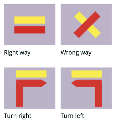
Each of the regional Azores hikes begins with a large sign. Read the sign for the map and hike overview. At the major intersections there are often labeled signposts. Also, throughout the hike, there are red and yellow signs. A horizontal yellow and red sign indicate that you’re on the trail. An arrow indicates that you should turn that direction after the arrow. The “X” sign signals that you are NOT going the correct way. Note that if you do an Azores regional hike backwards, it may be more difficult to see the signs. Also, there are a few “Grand Routes” on some of the smaller Azores islands. These markers use the same symbols, but the colors are white and red.
As we noted above, the Visit Azores app has information on all the regional hikes. Once you’re on the trail, use the Visit Azores App to follow your progress on the trail. To access the tracking feature, click “See Map” in the upper right after you’ve opened a hike. This feature uses GPS, so you can follow your progress, even if you don’t have cell service. Just make sure to open the hike and click “See Map” prior to losing service.
There is one downside to both the Azores Trails website and Visit Azores App. You can’t easily get directions to the hike because neither open directly into Google Maps. That’s why we added the start of every hike on our interactive Google map, so you can easily get directions. The map also includes our comments on every Sao Miguel hike, including how long it took us to complete the hike.
What to Pack for and Bring on Your Azores Hike
Azores weather is temperate, thanks to the gulf stream. The average highs and lows are between 50°F to 75°F all year round. The record high and low temperatures in Ponta Delgada (the biggest city in the Azores) are not much different than the averages: 84°F and 38°F.
But, Azores weather is also unpredictable. It’s said that you can see four seasons in a day in the Azores. So on any given day, you may see spring, summer, fall or winter weather. The high humidity can also make the “real feel” higher or lower than the actual temperature. For example, a sunny and humid 65°F day in January can fee 75°F. Or a cool day in the summer, can feel chilly if it’s overcast and windy.
Because of the unpredictability, pack layers for hiking in the Azores. On the upper body, start with short sleeves. You can work up a sweat on an Azores hike, especially if it’s sunny. During the winter, add a long sleeve shirt and either a vest or light jacket. It’s often overcast and windy at higher elevations in the winter. For your legs in the winter, pack mostly yoga or other comfortable pants for hiking. Shorts are also doable for Azores hiking in the winter if you can handle 50-60s °F.
In the summer, you can pack mostly shorts and short sleeves for hiking in the Azores. But it’s also worth bringing a pair of pants, a long sleeve shirt, and a light jacket for the higher elevations. So you’re prepared for the occasional winter day in the summer.
The spring and fall in the Azores are even trickier to pack for. Because it’s even harder to predict the weather. That being said, September is typically more like the summer months and November and March are more like the winter months.
Whenever you visit the Azores, always pack a rain coat. The Azores islands are green for a reason. It can rain any month of the year. Also, bring a bathing suit and sandals in the summer, there are some hikes that include a beach or swimming hole.
When you’re in the Azores hiking, don’t forget to bring:
- A hat, sunscreen, and sunglasses, because you’ll usually see the sun at some point during the day.
- Take advantage of the amazing tap water and bring a reusable water bottle.
- Azores hikes often have steep ascents and descents, so bring Band-Aids on your hike in case you get blisters.
- Hiking shoes are not a must in the Azores, so you can get by with running shoes. But hiking shoes are especially helpful for when the trails get muddy. Which happens often with all the rain.
- Finally, don’t forget your cell phone. You can use GPS to track your progress on your Azores hike using the Visit Azores App (see above). A phone is also helpful n case someone gets hurt.
How to Plan for Unpredictable Weather on an Azores Hike
As we’ve noted, Azores weather can be unpredictable. But there are a few ways to prepare for this unpredictability! First, Wind Guru is the best Azores weather app/website. Wind Guru provides the most accurate information on wind, cloud cover and precipitation. Your typical weather websites like weather.com are helpful for approximate temperatures but nothing more.
Next, each Azores island has live webcams that are viewable on the Spot Azores website. So you can see real time what the weather looks like a different locations. You can also download the Spot Azores IOS App or Android App.
The webcams are especially helpful, because even though the islands are small, they have microclimates. So weather can be different on different parts of an Azores island. It is however, typically nicer on the coasts than inland. And if it’s a little cloudy or rainy on the coast, it can clear up quickly. Also important to know if you want to check out one of the Azores amazing beaches. The temperate weather means that it’s never too cold, and the sun will usually come out at some point.
An exception are hikes to elevated peaks where it can be foggy. For example, on Sao Miguel island, it’s most likely to be cloudy at Lagoa do Fogo and Sete Cidades. And foggy can often mean zero visibility. So check the webcam before you start a hike, and skip it if you can only see fog on the webcam.
Finally, the best piece of advice is to accept the unpredictability. Don’t try to have a strict Azores hiking schedule in mind before you arrive. That is why we advise in the Travel Honey itinerary to stay as flexible as you can and check the Spot Azores webcam app each morning to decide what to do.
How to Safely and Respectfully Hike in the Azores
Azores hiking trails often go through private property, so make sure you stay on the trails. There are not typically any trash receptacles, except i the hikes go through a town. So, make sure to carry out your trash. If there are locked gates, don’t unlock them! Gates and fences are often to keep in livestock, which are how many Azorean families earn their livelihood.
If there is an emergency on a hike, dial 112. On Sao Miguel, there is an emergency room at Hospital do Divino Espírito Santo in Ponta Delgada. Pharmacists are knowledgeable and more drugs are available over the counter than in the U.S. A pharmacy is a good place to start if it’s not an emergency. If it’s after hours, pharmacies rotate which one is open 24 hours which can be found here (choose town on the left side).
If it’s not an emergency, you can also go to a centro de saude (health center), which have (mostly) English speaking doctors. If you’re from the US., you’ll likely need to pay out of pocket and will be reimbursed depending on your insurance. The out of pocket costs are usually lower than in the U.S.
A Summary of Hikes on Sao Miguel Island in the Azores
Sao Miguel has the most Azores hiking of any island. We’ve summarized and provided our first hand accounts of each of the regional hikes on Sao Miguel island, plus a few others. We’ve divided each of the hikes by region.
Hiking Around Ponta Delgada, Relva, São Roque, & Lagoa
Rocha da Relva is a 5.5km/3.4m hike that’s rated as medium difficult.It’s a lot of steep uphill/downhill, but the trail is wide and mostly paved. It’s technically circular because the total mileage is both ways, but you basically go out and come out. The trail starts with great views as you walk down a mostly paved trail past a few gardens/houses to a small village. It takes on average 3h but you can do it in about 2h with a swift pace (1.5h if you skip the steep hill down to the ocean at the start). This is in Relva, near the airport.
Rota da Água – Janela do Inferno – PRC37SMI
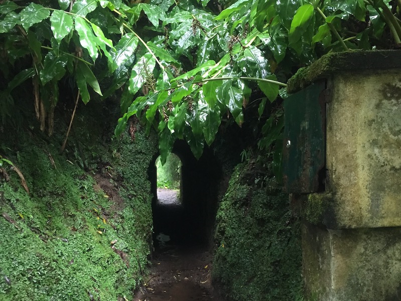
Rota da Agua is a 7.6km/4.5m circular route near Lagoa. The hike is rated easy, but it’s one of the longer hikes and can get a little muddy if it’s been raining. The hike is mostly through forests, so it’s OK if the weather is bad. You’ll go through long tunnels though, so make sure you have your cellphone or a flashlight! The average time is 2h30h but you can do in 2h.
Azores Hiking Around Sete Cidades & Northwest Coast
Azores hiking on the northwest coast of Sao Miguel is focused on viewpoints of the famous double crater lake of Sete Cidades.
Mata do Canário – Sete Cidades – PR4SMI
Mata do Canario is a 11.8km/7.3mi (one way) hike that takes about 3 hours. The trail is rated as easy, but it’s one of the longer trails on the island. You go up and around the lakes of Sete Cidades and then walk down into town. So there is a lot of downhill (or uphill if you do the trail backwards!). The end of the trail, which goes into the town overlaps with another hike “Vista do Rei – Sete Cidades-PR3SMI”. Check the Sete Cidades webcam for both hikes. If it’s foggy, it’s best to skip this hike.
Serra Devassa is a 5km/3m circular hike that’s rated medium difficulty. The average time is 2h, but you can do it closer to 1h15 with a swift pace. Parts are steep and it can get muddy, so it’s not great for kids/ less abled if it’s been raining (and hiking shoes would be recommended). It’s also better to do if there’s not heavy clouds because you miss out on the views.
Vista do Rei – Sete Cidades-PR3SMI
Vista do Rei is a 7.7 km/4.4 mile (each way) trail is rated as easy and takes about 2h. It’s mostly downhill, starting at Vista do Rei viewpoint, ending in the town of Sete Cidades. It goes along the road for a bit, so it’s great for views but it’s not secluded. The end of the trail, which goes into the town overlaps with another hike “Mata do Canário – Sete Cidades – PR4SMI”.
Altalho dos Vermelhos – PRC33SMI
Altalho dos Vermelhos is a circular 5.4km/3.4 mile hike that’s rated medium difficulty and takes on average 2h, but you can do it in 1h30m with a swift pace. The trail is on both paved and dirt roads through a village, along the coast and then back through farms. The trail has steep parts and drop-offs, so it’s not a great for kids. It’s a great option for a short hike in the northeast part of Sao Miguel island, especially when the mountaintops are cloudy (but if you want views of the water, skip if it’s foggy in Mosteiros).
Azores Hiking on the North Coast – São Vicente Ribeira Grande and East
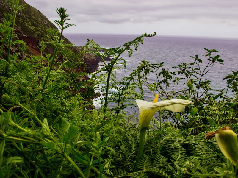
Azores hiking on the north coast of Sao Miguel is some of our favorite. There are amazing coastal views and secluded beaches to visit.
Vigia de Sao Pedro is a 6.5km/4 mile linear route and is rated as easy. It on average takes 1h30, but you can finish it in a little over 1h if you have a quick pace. So that’s 8 miles and 2 to 2.5 hours round-trip. It’s one of the flatter hikes on Sao Miguel with a few rolling hills. It’s a mix of paved and dirt roads that are a little muddy in the winter. The trail is along the coast and there are no fences, so it’s not great for kids.
Caldeiras da Ribeira Grande – Salto do Cabrito PRC29SMI
Caldeiras da Ribeira Grande is a 7.5 km/4.7m circular hike that’s rated as easy. You have to go on a grated walkway and stairs above waterfall, so it might be scary for someone afraid of heights. The average time is 2h30 but it will take a bit longer if you stop for a swim in the waterfall. It’s mostly in the trees, so is a good option if the weather isn’t great. There’s also a point where the road can get flooded, so be prepared to take off your shoes to cross it.
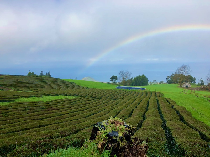
Chá Gorreana is circular hike that is 3.4km/2.1m. It is some of the only Azores hiking that you can do on a tea plantation! The hike is listed 1h30m, but you can do it in 50 minutes if you have a swift pace. It’s mostly through the trees, so it’s a good option if the weather is bad. It’s also a good option for kids/less abled because it’s not too steep or long. You can also cut the hike short and just walk through the tea bushes (you also might see goats!). But the trails can be a little muddy if it’s been raining. You park at the Gorreana Tea factory.
Caminho da Água da Gorreana
Caminho da Água da Gorreana is a municipal trail, so it’s not on the Visit Azores App or website. It’s about .6km/1m each way and takes about 35 minutes with a swift pace. It’s a relatively easy hike with a bit of up and down and there’s a point where you have to cross a creek with some rocks so not great for kids. It’s a good hike to do if the weather is bad, because it’s mostly through the forest.
Pedra Queimada – Lajinha – Degredo – PRC36SMI
Pedra Queimada is a 6.6 km/3.75m (a little longer if you walk down to the pools) circular hike. The hike is rated as medium difficulty because it has a lot of uphill but it’s not super steep except for a small part. You start the hike going uphill from the town and get great views of the coast. It’s a mix of dirt trails through grassy hills then a bit along the road and through town at the end. It’s pretty to do at sunset. The average time is 2h30 but you can finish it in 1h45 with a swift pace.
Praia da Viola is a 5km/3.1m (each way) linear hike that’s rated as easy (but there is some steep uphills). The hike begins with beautiful views along the coast. You also visit a secluded beach and see old water mills. It takes on average 2h (each way) and you can do it in a little less if you have a swift place.
Moinhos da Ribeira Funda – PRC35SMI
Moinhos da Ribeira Funda is a short 3.3km/2 mile circular route that is rated medium difficulty because of steep uphills. This hike typically takes between 1h15 – 2h. There is an optional detour to waterfall and amazing ocean views! Go when the weather is nice.
Lomba d’el Rei – PRC38SMI A 4.5 km/3.75m
Lomba d’el Rei is a circular hike rated as medium difficulty. The average time is 2h, but you can finish sooner with a quick pace. It’s probably our least favorite hike on the north coast. It starts with a very steep paved road but then most of the trail can be slippery. It’s also mostly in the woods, so you miss out on the great coastal views. But it’s a varied hike, so you’ll walk through a forest, along streams and past an old water mill.
Padrão das Alminhas – Salto da Farinha – PR21SMI
Padrão das Alminhas is a linear hike (5km/3m each way) rated as medium difficulty as there are some steep narrow parts. The average time is 2h but you can finish sooner with a quick pace. It’s a mix of lovely coastal views and walking in the trees to Poço Azul, a pretty blue lagoon where you can swim.
Azores Hiking Around Lagoa do Fogo
Hike at Lagoa do Fogo
This is a short steep narrow hike down to Lagoa do Fogo that is not on the Visit Azores App or website. It’s about 1h down to the lake and back with a swift pace. You can walk as far as you want around the lake depending on the water level. There’s no swimming allowed because Lagoa do Fogo is a natural reserve. There is also a short trail that goes up and to the left above the lake, which gives a different perspective than the viewpoint near where you park.
Hiking on the Southeast Coast: Caloura, Vila Franca do Campo
Praia – Lagoa do Fogo – PRC2SMI
Praia – Lagoa do Fogo is a 11km/6 mile hike that is technically circular, but it’s really linear, the distance just includes the return. The route is rated medium difficulty and is listed as taking 4h, but you can finish it in less if you have a swift pace. You walk a bit in the forest and through pastures along a levada (aqueduct), but you also get some nice views along the south coast if the weather is clear. The hike ends at the shores of Lagoa do Fogo. It can be muddy.
Azores Hiking Trails Around Furnas
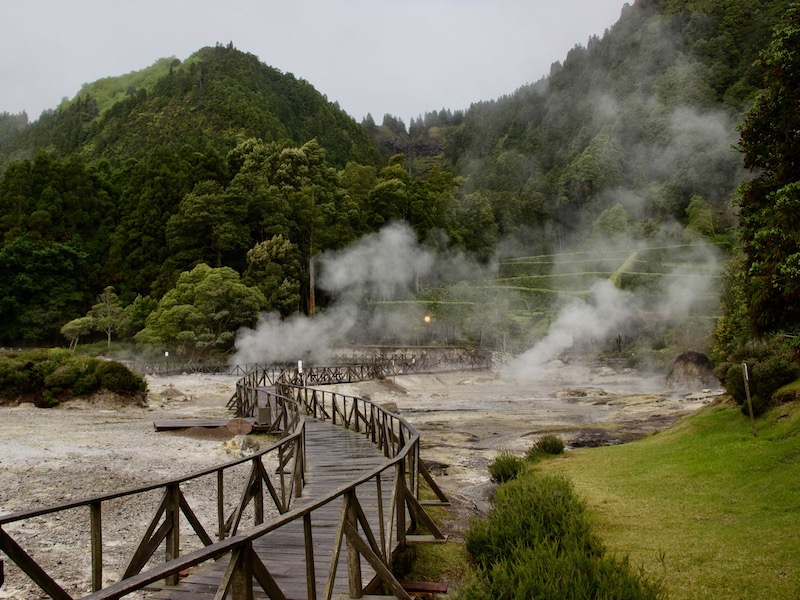
Lagoa das Furnas – PRC6SMI
Lagoa das Furnas is an easy flat, circular trail around Lagoa das Furnas that begins/ends in the town of Furnas The full hike takes around 3h (9.5km/5.9m). But if you only walk around the lake, it’s 4.5m/1.5h. You’ll pass Caldeiras da Lagoa das Furnas (bubbling volcanic fumaroles). Here, at 11am/12pm, you’ll see cozidos (stews cooked by the earth’s heat in pots) removed from the ground. On the hike, you will also pass a unique gothic church. There aren’t spectacular views, so it’s good in so/so weather. It’s also great for kids or the less abled.
Hiking on the East Coast – Povoação to Nordeste
Pico da Vara is a 7 km/6.8 miles (total) hike that’s rated as difficult. It’s listed as a circular hike, but it’s linear, the total just includes the return. The hike is mostly up a steepish trail to the top of Pico da Vara, the highest point on the island of São Miguel at 1,103m. The hike is best to do in good weather, when you can see the amazing views. The average time is 3h but you can do it in a little more than 2h with a swift pace. You must complete a form online to complete the hike (see the link to this hike provided at the start of the description)
Trilho do Agrião is a linear route that is 7.6km/4.7 miles each way. The hike is rated as medium with an average time of 3h. You’ll start at the beach in Povoação then walk through woods, crossing a stream. Most of the hike is along the coast with beautiful views, so it’s best to do when the weather is nice
Ribeira do Faial da Terra – PR11SMI
Ribeira do Faial da Terra is a linear route that is 6km/3.7 miles each way. The hike is rated as medium difficulty with an average time of 2h. You’ll walk through the forest, see a waterfall, and walk through farms. You have some views, but this is a decent hike if the weather isn’t great.
Faial da Terra – Salto do Prego (also called “Sanguinho”) – PRC9SMI
Faial da Terra – Salto do Prego is a 4.5km/2.8m circular route, that’s rated as medium difficulty. It typically takes about 2h. You’ll walk through the forest, see a waterfall, and get a great view of the town below. You have some views, but it’s decent hike if the weather isn’t great.
A 6km/3.6m route that is rated as medium and takes on average 2.5 hours. This small circular route in Lomba da Fazenda, Nordeste, which begins at the garden near the church of Nossa Senhora da Conceição. You’ll see old watermills, go through a forest, and get great views along the coast.